Brits are bracing for a six-day ‘mini-heatwave’ that should bring us the hottest day of the year so far. The current warmest day was April 4, when temperatures rose above 23C for the first time, but Met Office forecasters expect that record to be smashed next week.
Temperatures are expected to creep upwards on Sunday, with 21C possible in London, 18C in Cardiff and 19C in Manchester at around 4pm. Monday should bring temperatures above 20C right across England and Wales, with the capital possibly reaching 23C according to the Met Office. Scotland and Northern Ireland will hover around 16C and 17C.
Tuesday should be the first day next week that could become the new hottest day of the year, with Met Office temperature maps suggesting the mercury could rise to 24C in and around London. Cardiff and Manchester are expected to hit 22C, with parts of central Scotland also rising to 20C.
And Wednesday is then expected to break the record again, with 25C on the cards in the south-east of England. Northern parts of England could rise to 24C, with 23C coming in Wales, 21C in Scotland and 19C in Northern Ireland.
The outlook for Thursday looks similar to Wednesday, with 25C on the cards once again in and around London. Much of the rest of England should hit at least 22C, with 23C possible in Cardiff. Friday looks to be a notch or two cooler than Thursday, with highs of 21C to 23C expected across England and Wales.
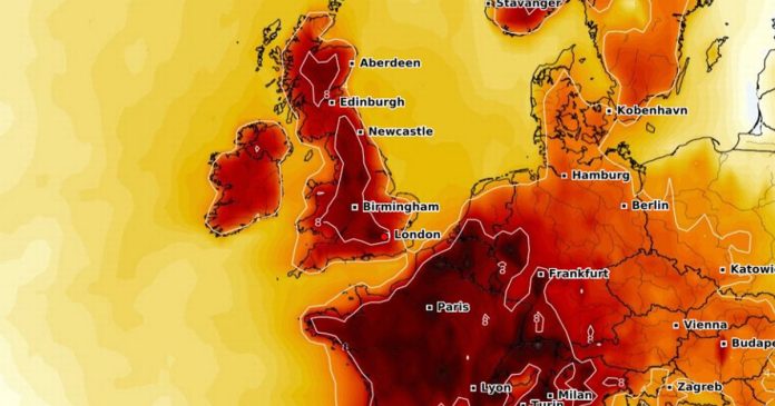
Temperature anomaly maps – which highlight the difference between expected temperatures and the seasonal average – have turned deep red for next week right across Europe, suggesting the mercury will rise well above what can be expected for this time of year.
The Met Office has said temperatures should start “climbing” at the start of next week. Its forecast for Sunday to Tuesday states: “Cloudy with outbreaks of rain in the northwest Sunday, otherwise dry with sunny spells. Similar into next week, but temperatures climbing, feeling warm by day across England and Wales.”
Thereafter, the national weather agency says “sunny spells are likely across most regions” with “above average” temperatures on the cards. However, unsettled weather could also bring “thundery” conditions at times.
The Met Office forecast for April 29 to May 8 states: “Widely fine and dry across the majority of the UK for the first couple of days of this forecast period. Clear or sunny spells are likely across most regions, although the north and northwest of Scotland and Northern Ireland could be cloudier with a little light rain or drizzle at times.
“Into early May, it will probably begin to turn more changeable, with dry, settled periods interspersed with some spells of unsettled weather. This will bring some showers or longer spells of rain at times, which could be heavy and thundery in places. Temperatures are likely to be widely above average to begin with, but will probably fall nearer normal as we move into early May.”
At Reach and across our entities we and our partners use information collected through cookies and other identifiers from your device to improve experience on our site, analyse how it is used and to show personalised advertising. You can opt out of the sale or sharing of your data, at any time clicking the “Do Not Sell or Share my Data” button at the bottom of the webpage. Please note that your preferences are browser specific. Use of our website and any of our services represents your acceptance of the use of cookies and consent to the practices described in our Privacy Notice and Cookie Notice.


