

On Thursday, while northern and central Manitoba experienced a wintry spell, the southeastern part of the province was under a severe thunderstorm alert, with potential for isolated tornadoes.
Environment and Climate Change Canada issued a blizzard warning for northern regions, indicating that strong winds of 70-80 km/h, accompanied by blowing snow, would create prolonged periods of near-zero visibility. By the time this weather system exits on Saturday, total snowfall is anticipated to reach between 30-50 centimetres.
The warning area extends from Thicket Portage, located about 50 kilometres south of Thompson, all the way north to the border with Nunavut. This includes the city of Thompson, where La Voie du Nord school was closed on Thursday.
As of late Thursday afternoon, Churchill and the surrounding areas near Hudson Bay were not under any warnings.

Drivers in northern Manitoba will frequently need to clear ice from their vehicles. Ice pellets in Flin Flon resulted in rapid freeze-ups on Thursday morning. (Eric Westhaver/CBC)
Parts of west-central Manitoba are also facing hazardous conditions and remain under a winter storm warning. An expected five to ten millimetres of freezing rain will be followed by approximately 15 centimetres of snow.
The system that struck on Thursday is predicted to persist until Saturday, according to Environment Canada’s forecast. Areas affected include Flin Flon, Cranberry Portage, Sherridon, and Snow Lake.
Additionally, another freezing rain warning extends across central Manitoba from The Pas through Gods Lake to the Ontario border.
Heavy freezing rain is anticipated to fall throughout the day and into the evening on Thursday, with amounts potentially exceeding five millimetres, according to Environment Canada.

During Thursday’s storm, few pedestrians were seen on Flin Flon’s Main Street. (Eric Westhaver/CBC)
In Flin Flon, many businesses closed for the day, including all local schools. School bus services were suspended on Thursday morning for both Thursday and Friday.
The issues in Flin Flon were not due to snow, but rather freezing rain and ice pellets that hit the area, along with strong winds and thunderstorms early on Thursday.
While roads were being cleared, they were quickly covered again with ice pellets, causing several drivers to get stuck on treacherous streets.
Shortly before 3 p.m., Manitoba Highways announced road closures due to poor visibility and driving conditions for:
- Highway 391 from Lynn Lake to Leaf Rapids.
- Highway 394 from Highway 391 to the Saskatchewan border.
- Highway 396 from Lynn Lake to Fox Mine.
Manitoba 511 reported several other northern highways were either “covered” or “partly covered” as of late Thursday morning, with snowplows actively monitoring those routes.
Severe thunderstorm alert
In a separate development, Environment Canada issued a severe thunderstorm watch for the southeastern region of Manitoba on Thursday afternoon.
This system has the potential to generate strong wind gusts reaching up to 90 km/h, large hail, and heavy rainfall, with the risk of an isolated tornado developing on Thursday afternoon or evening, according to the agency’s alert issued just after 3 p.m.
The watch encompasses most of the southeastern shore of Lake Winnipeg and extends to communities just east of Winnipeg, such as Dugald and Oakbank. It also covers the communities of Lac du Bonnet, Seymourville, and Buffalo Point.
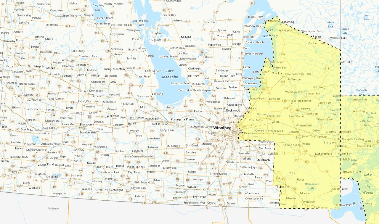
The areas affected by the severe thunderstorm watch are highlighted. (Environment and Climate Change Canada)
A moving low-pressure system is contributing to scattered thunderstorms that range from strong to severe across the area, as indicated in Environment Canada’s alert.
Residents are advised to prepare for severe weather and to seek shelter in a basement or interior room if threatening weather approaches.
Heavy rainfall can lead to flash floods and decreased visibility, while strong gusts of wind may damage trees, buildings, and overturn vehicles, as stated in the watch. Large hail poses a risk of significant damage and injury.